This campaign will allow the institute to accurately assess the production and efficiency of the new wind turbines to be installed as part of the technological upgrading of its three oldest wind farms.
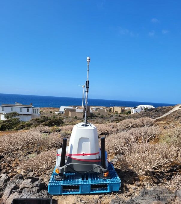
The Instituto Tecnológico y de Energías Renovables (ITER), an entity dependent on the Cabildo Insular de Tenerife, is carrying out since June 15 a wind resource evaluation campaign at its facilities in the Industrial Park of Granadilla de Abona. For this purpose, a LiDAR (Light Detection And Ranging) equipment is being used, a device capable of measuring wind speed and direction at different heights by means of light pulses, which will allow characterizing the current wind regime of the area and technically assessing the new wind turbines to be installed.
The initiative is promoted by ITER and Enel Green Power España, and is developed in the context of the technological adaptation of the 4.8 MW MADE, 5.5 MW ENERCON and 2.4 MW Experimental wind farms, which have been operating for more than twenty years and are nearing the end of their useful life. The adaptation project is aimed at updating the existing facilities by replacing their twenty-nine wind turbines with five new high-efficiency machines.
The measurement campaign is expected to last one year and will allow to analyze the energy potential of this new wind project, as well as to ensure the suitability of the new wind turbines in relation to the wind profile of their future locations in the ITER facilities.
The LiDAR system is capable of obtaining highly accurate measurements up to two hundred meters in height, and at different levels, which, in combination with its portable and lightweight nature, makes it easy to adjust the measurement needs to the locations and different hub heights foreseen for the projected wind turbines, and to modify them in the event of possible project redefinitions.
The data obtained as a result of this campaign will allow expanding ITER’s meteorological database, which is currently fed with data from Torre, Solten and Euclides stations up to 45 meters high. Knowing the tendency of the wind sector towards wind turbines of increasing altitude and rotor diameter, the availability of measurement systems that allow reaching higher altitudes will contribute positively to the historical data of ITER to extend its interest and usefulness at the level of analysis of surrounding wind installations, in their development and operation phases.
These data will also allow the optimization of wind power generation forecasting systems, which ITER develops and maintains in continuous growth through the DELFOS and NEXO projects, favoring the development of a more efficient wind farm management and operation strategy, and with it, the optimization of energy production and the reduction of associated costs.