The tests carried out last November have allowed to validate and improve the design, performance and safety of the unmanned aerial vehicle (UAV) in a controlled and realistic environment, thus advancing the PERSEO project towards Maritime Monitoring with Innovative and Sustainable Aerial Technology.
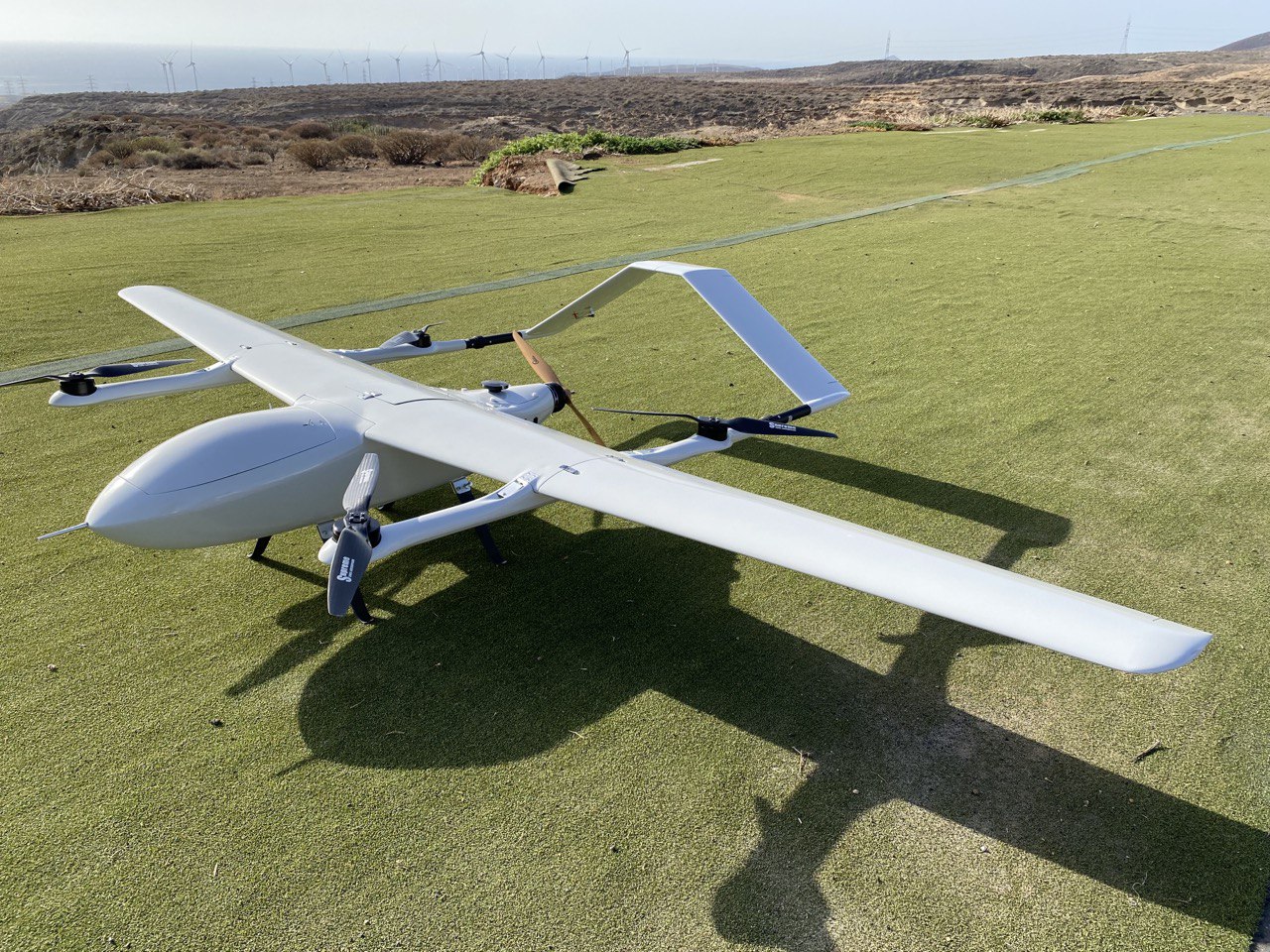
The Instituto Tecnológico y de Energías Renovables (ITER), an entity dependent on the Cabildo de Tenerife, has started the drone test flight campaign of the PERSEO project. PERSEO project. This project aims to monitor the marine ecosystem through the processing of multispectral images collected by an unmanned aerial vehicle (UAV).
The objective of these flight tests has been to validate and improve the design, performance and safety of the UAV in a controlled and realistic environment, i.e. to ensure that it meets the required quality and performance standards prior to its implementation in practical applications. This experimental vehicle presents challenging particularities, such as its vertical take-off capability and its solar energy collection system, which has required meticulous prior preparation. From the assembly of electronic components to the configuration of communication systems and the development of a power system, every detail has been carefully attended to. In addition, authorization was obtained to operate at the “El Vallito” aerodrome, a space duly authorized for operations with experimental aircraft. .
The tests carried out last November 2023 in “El Vallito”, with stable and safe weather conditions for flight execution, have been essential to validate the UAV in multiple flight configurations. This included vertical take-off and landing tests to validate stability and vertical rotors, the evaluation of the transition from VTOL (Vertical Take-Off and Landing) mode to glider, an analysis of energy performance and maneuverability in cruise phase and finally a validation of the transition from glider to vertical mode for final landing.
These tests have been fundamental to identify areas for improvement, especially in terms of the vehicle’s reduced steering angle. Aware of the importance of ensuring safety and avoiding possible risk situations due to obstacles, the implementation of geofencing, a technology that establishes virtual boundaries or “geofences” in real-world geographic areas, within which drones can operate, is being considered.
Following the execution of this task, significant progress has been made in the validation and continuous improvement of this innovative unmanned aerial vehicle. The next steps will focus on implementing solutions to ensure its optimal performance in terms of energy, imaging and safety, pending a second test flight campaign once the integration of solar cells and multispectral image sensors has been completed.
The PERSEO project (CPP2021-008527)coordinated by the Robotics Unit of ITER, will have a duration of 36 months and is funded by the Ministry of Science and Innovation and the State Research Agency (10.13039/501100011033) and by the European Union in the framework of the EU Recovery Plan Next Generation EU and the Spanish Recovery, Transformation and Resilience Plan (PRTR). The scientific consortium of the project is completed by the University Institute of Applied Microelectronics of the University of Las Palmas de Gran Canaria, which will develop the electronic system responsible for the capture and processing of multispectral data, the Oceanic Platform of the Canary Islands (PLOCAN) and the company Elittoral, both organizations in charge of interpreting the data obtained.
More information at https://iter.es/plataforma-aerea-autonoma-solar-para-la-monitorizacion-de-eventos-contaminantes-en-el-ecosistema-marino/